
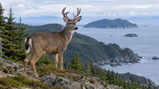
Sitka black-tailed deer occupy a landscape that changes quickly with weather, elevation and exposure. That makes a coastal hunt less about covering ground at random and more about choosing habitat that still offers food, shelter and usable travel routes when conditions turn wet or snowy. A sound plan begins with the island or mainland unit, then narrows to forest edges, beach margins, creek bottoms and alpine transitions. It also leaves room for legal checks, vessel logistics and a clean decision to pass when the animal, shot or recovery route is not right.
Where coastal deer find workable country
Across southeastern Alaska and other parts of the coastal range, these deer use a mosaic rather than one uniform habitat type. Mature conifer forest provides cover, while openings, avalanche paths, muskeg margins, shorelines and disturbed ground can produce more accessible forage. The best country may look unremarkable on a map: a narrow strip between dense timber and a low, brushy opening, or a bench above a tidal flat.
Island geography matters. Deer may be concentrated on certain sides of an island because wind, snow depth, elevation and forest structure differ across short distances. Saltwater does not make every shoreline productive. Some beaches offer little cover or browse, while others connect beach grass, alder and timber into a useful feeding route. Study access, escape terrain and visibility together rather than selecting a drainage only because it looks large.
How weather changes the seasonal picture
Early in the season, mild conditions can leave animals spread through forest edges, low clearings and higher green slopes. Fresh browse may be available in several places, so glassing a single open face is unlikely to tell the whole story. Wet vegetation also hides tracks quickly, and heavy rain can make a promising route difficult to follow.
As temperatures fall, forage and shelter become more decisive. Snow can push deer toward lower elevations, wind-sheltered timber and south-facing slopes, but the response is not identical on every island. A thin covering may improve visibility without changing movement much. Deeper or crusted snow can make open ground less attractive and increase the value of protected benches, creek corridors and dense forest margins.
The practical check is current, not theoretical: look for fresh tracks, clipped stems, droppings, beds and recent browsing. Old sign can confirm that deer use an area, but it cannot prove that the area is productive today. Wind direction, rainfall and overnight snow may change the answer before the next tide cycle.
Reading forest edges without overcommitting
An edge is useful when it joins two needs. Deer may feed in a low opening and retreat into timber, or move along the boundary between young growth and older forest. Look for several clues working together: browse at a reachable height, tracks crossing rather than merely entering, beds with a clear view, and a quiet route that links cover to food.
Do not treat every straight line as a hunting edge. Logging history, windthrow and avalanche damage create different vegetation patterns and different visibility. A very dense stand may hold animals but make identification, safe shooting and recovery difficult. An opening with no nearby cover may be used briefly, yet offer little reason for a deer to remain there during daylight.
Glass from a stable position before moving. Movement along the edge can disturb animals that would have appeared with more patience. If visibility is poor, change the observation point rather than forcing a close approach through brush.
Alpine transitions reward careful timing
Higher ground can be productive when green forage remains available, particularly where alpine vegetation meets stunted timber, rock or brush. These transition lines create both food and escape cover. They can also expose a hunter to fast-changing wind, fog and rain, so the visual advantage may disappear quickly.
Use elevation as a condition-based choice. If snow has settled above the timberline but low country remains wet and open, the boundary between the two may be more useful than either extreme. If wind is strong or cloud obscures a safe route, drop lower and reassess. A deer seen across an unsafe slope is not a worthwhile opportunity.
Alpine transitions are also easy to overread. Green patches may be old, sparse or difficult to reach without crossing fragile ground. Keep the recovery route in mind before committing to a glassing point or shot.
Match the hunt to the current regulations
Season dates, open areas, bag limits, legal methods and permit requirements can differ by game management unit and may change through emergency orders or annual regulation updates. Before travel, check the current Alaska Department of Fish and Game hunting regulations for the exact unit, season and license situation that applies to the trip. Do not rely on a previous season's dates, a general internet summary or another hunter's recollection.
Confirm boundaries with current maps and ask the guide or transport operator which unit the landing enters. A vessel route can cross into a different regulatory area more easily than expected. Clarify required harvest reporting, tagging and transport procedures before departure, and keep the applicable documents accessible in wet weather.
Legal compliance is only the baseline. Confirm that the intended firearm, archery equipment or other method is allowed in that unit, and follow all safety rules for handling and shooting from uneven ground. If a rule is unclear, pause the hunt and verify it through current official guidance rather than guessing.
Prepare for a respectful, recoverable hunt
A responsible plan starts with the animal and ends with the meat. Choose opportunities where identification is certain, the backstop is safe and the likely recovery route is manageable. Avoid shots toward skylines, across water or into dense vegetation that prevents a clear assessment. Weather can turn a short pack into a serious problem, especially when a vessel pickup depends on a narrow window.
Discuss expectations before leaving the boat: who carries navigation gear, how a downed animal will be located, what happens if visibility closes in, and when the group will stop. Pack clothing and communication equipment for a delay, not just the forecast. Waterproof bags, spare layers, food, first-aid supplies and a reliable way to signal the vessel support both safety and stewardship.
Minimize disturbance around camps, shorelines and wildlife concentrations. Pack out waste, keep meat protected from weather and scavengers, and avoid leaving unnecessary tracks through sensitive vegetation. The strongest field decision may be passing on an animal that cannot be recovered cleanly. That is not a failed hunt; it is responsible hunting in a landscape where conditions, law and consequences all matter.